A New Chapter in Conservation: Motus Tower Installed at Caw Caw Interpretive Center
Visitors walking near the rice fields of the Caw Caw Interpretive Center may notice a new silhouette rising above the marsh.
It’s an intricate antenna perched atop a tall pole. It may look like an old-school television receiver, but it’s far more meaningful. It’s the center’s newly installed Motus Wildlife Tracking System, a tool that will connect our Lowcountry landscape to a global network of wildlife research and migration science.
The Motus system is, at its heart, a worldwide collaboration. Using tiny, lightweight bands attached to birds, bats, and even large insects, researchers can follow the movements of tagged animals across continents. Each tag emits a unique signal. When an animal passes near a Motus tower, the signal is recorded, logged, and added to a growing database that reveals migration routes, stopover points, timing, behaviors, and flight speeds.
“We are so excited to install a Motus Wildlife Tracking System at Caw Caw Interpretive Center,” Natural History Interpretation Coordinator Kristina Wheeler said. She helped lead the project. “The data gathered provides fascinating insights into migration routes, timing, and behavior, connecting what happens here in South Carolina to patterns across the world.”
Caw Caw’s tower is a special addition to the network.
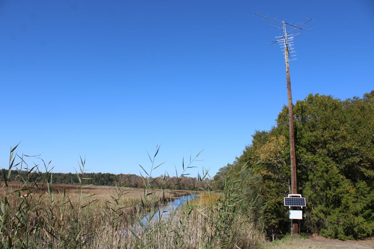
“This tower is a little more inland, which is cool,” Caroline Heape, Lead Stewardship Aide said. “It’s also solar-powered, so that's kind of a neat offset.”
The tower itself is a local story of reuse and adaptation. The tall pole once played a role in providing power in the region.
“The old power pole was then turned into an Osprey platform which we’ve since moved,” Heape explained. “We had about five platforms here on the property, but the Osprey are consistently only using one every year, so it was nice to find another use for this pole.”
Perched on top of this repurposed structure is an array of six directional antennas.
“There are three large and three small ones going in all sorts of directions, and the radius is around 15 miles,” Heape said. “This coverage allows the tower to detect tagged wildlife from a remarkable distance, silently listening for passing migrants day and night.”
Thanks to support from the Dominion Energy Charitable Foundation, the technical work of Charleston County Park naturalists and maintenance staff, and the expertise of partners at Audubon South Carolina, the tower is already up and running.
It didn’t take long for the first data to arrive. Early this fall, the tower detected its very first species. An American Kestrel began its journey in the Chesapeake Bay region before passing over Caw Caw on October 16 and continuing south toward Savannah. That detection illustrates the power of the Motus network revealing how a single bird uses landscapes hundreds of miles apart.
The reach of this system also expands Caw Caw’s role as a place of learning.
“We hope to use it for storytelling,” Heape said. “It really does help tell a bigger conversation about conservation. You can tell a child, ‘Hey, a bird that was here crossed borders and a lot of land to get here.’ So we’re able to show that conservation doesn’t only need to happen in this area. It’s great for education.”
As more animals pass overhead, tagged birds and unknown travelers alike, the tower will record their journeys. Guests and community members can even explore detections from around the world by visiting motus.org, where flight paths, species lists, and movement patterns are visualized.
With this installation, the Caw Caw Interpretive Center becomes part of a continental conversation. It links local stewardship to international conservation science. It’s also another reminder that the landscapes we care for here in Charleston County play a small but essential role in the lives of wildlife traveling thousands of miles each year.